On December 13, 1642 C.E., two small Dutch ships crept through heavy swells toward an unfamiliar coastline on the northwestern edge of the South Island. The men aboard had no name for what they were seeing. They were the first Europeans ever to see it. Abel Tasman, navigator and servant of the Dutch East India Company, had just added a new landmass to the European map of the world — though he would leave without ever setting foot on it.
What the evidence shows
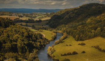
- Abel Tasman New Zealand: On December 13, 1642 C.E., Tasman’s ships Heemskerck and Zeehaen became the first European vessels to sight New Zealand, approaching the northwest coast of the South Island.
- VOC expedition: The voyage was commissioned by the Dutch East India Company (VOC) and its Governor-General Antonie van Diemen, primarily to find new trade routes and locate rumored southern lands rich in gold.
- Māori encounter: Within days of arrival, a violent confrontation in what Tasman called Murderers’ Bay left four of his crew dead — and Tasman sailed away without ever landing on New Zealand soil.
A merchant seaman turned navigator
Abel Janszoon Tasman was born around 1603 C.E. in Lutjegast, a small village in the Dutch province of Groningen. He came from no particular privilege. He was largely uneducated and learned navigation entirely through experience, working his way up through the ranks of the VOC over more than a decade of hard voyaging.
By 1642 C.E., he had sailed to the Maluku Islands, Japan, and across much of the known maritime world. The VOC trusted him enough to hand him command of one of the most ambitious expeditions it had ever commissioned: a sweep through uncharted waters east of the Cape of Good Hope, searching for the fabled southern continent and whatever wealth it might hold.
He left Batavia — now Jakarta, Indonesia — on August 14, 1642 C.E. with two ships and a crew that would spend the next several months testing the edge of the known world.
The route that changed the map
Tasman’s path was a feat of sustained navigation. He sailed west to Mauritius, then plunged south into the Roaring Forties — the band of relentless westerly winds between 40 and 50 degrees south latitude. No European expedition had sailed this far east through those latitudes before.
On November 24, 1642 C.E., he reached the west coast of Tasmania, which he named Van Diemen’s Land after his patron. He followed the coast, formally claimed the territory on December 3, then turned east — and nine days later, sighted New Zealand.
Tasman named it Staten Landt, believing it might connect to an island of the same name near the southern tip of South America. He was working from incomplete knowledge and old maps, including distorted echoes of Marco Polo’s writing that had placed a gold-rich phantom island somewhere in the southern seas. He was mapping the unknown with the tools his age could offer.
The name did not stick. A year later, Dutch cartographer Joan Blaeu renamed it Nieuw Zeeland, after the Dutch coastal province of Zeeland — a name that, corrupted by later English usage, became New Zealand.
The Māori were already there
Tasman did not discover an empty land. The Māori people had lived in New Zealand for several centuries before his arrival, descended from Polynesian voyagers who had themselves navigated extraordinary distances across the Pacific. Their maritime traditions were as sophisticated as any in the world.
When Tasman’s ships anchored off the coast in mid-December 1642 C.E., Māori observed them. A place on that coast was given the name Tiropahi — “the place where a large sailing ship was seen” — a record of the encounter preserved in oral tradition. Attempts at communication between the two sides quickly broke down. A small boat crossing between Tasman’s two ships was rammed by a Māori canoe. Four Dutch sailors were killed. Tasman fired his cannons, sailed north, and never returned.
The encounter was shaped as much by mutual incomprehension as by hostility. Māori had no context for what these vessels were, and the Dutch had no means of meaningful communication. Both sides were reading a situation they had no framework to interpret.
Lasting impact
Tasman’s 1642 C.E. voyage was the first to establish — however imperfectly — that a significant landmass existed in the southwestern Pacific. His charts, though rough, gave European cartographers their first outlines of Tasmania and New Zealand’s South Island coast. They remained in use for more than a century.
When James Cook arrived in New Zealand in 1769 C.E., he carried knowledge built in part on Tasman’s work. Cook’s voyages, in turn, opened the door to British colonization — a process that brought catastrophic disruption to Māori communities through land confiscation, disease, and war. The map Tasman helped draw was eventually used against the people he had first encountered on its shores.
Tasman himself was largely unrewarded. The VOC considered his expedition a failure: no gold, no trade routes established, no friendly contact made. He continued to serve the company until his death in 1659 C.E., largely uncelebrated in his own time. It was later generations who would attach his name to an island, a sea, and eventually an Australian state.
His voyage also contributed to a growing body of knowledge about the Southern Ocean and the Roaring Forties — navigational understanding that would prove critical to global maritime trade for centuries.
Blindspots and limits
Tasman’s maps were incomplete and in places significantly wrong. He never circumnavigated either Tasmania or New Zealand, so European knowledge of both remained fragmentary for generations. The VOC’s framing of the voyage — as a commercial mission above all — also meant that scientific and cultural observation was largely absent from the record.
The violent encounter at what is now called Golden Bay cast a long shadow. It reinforced European assumptions about the danger of Indigenous peoples in unknown territories and shaped the early British approach to New Zealand in ways that contributed to lasting harm. The story of Tasman’s voyage cannot be told honestly without acknowledging what came after — for the Māori, the stakes of European contact were existential, not cartographic.
Even the idea of “first European” deserves a note of precision. Some researchers have investigated claims of earlier European contact, none of which have achieved scholarly consensus. Tasman’s 1642 C.E. sighting remains the accepted first.
What Tasman found, he barely touched. The land he named, he never walked. And the people he encountered, he never understood. His voyage was a beginning — imperfect, incomplete, and consequential far beyond what he could have imagined.
Read more
For more on this story, see: Wikipedia — Abel Tasman
For more from Good News for Humankind, see:
- Indigenous land rights win at COP30 protects 160 million hectares
- Ghana establishes marine protected area at Cape Three Points
- The Good News for Humankind archive on New Zealand
About this article
- 🤖 This article is AI-generated, based on a framework created by Peter Schulte.
- 🌍 It aims to be inspirational but clear-eyed, accurate, and evidence-based, and grounded in care for the Earth, peace and belonging for all, and human evolution.
- 💬 Leave your notes and suggestions in the comments below — I will do my best to review and implement where appropriate.
- ✉️ One verified piece of good news, one insight from Antihero Project, every weekday morning. Subscribe free.