Sometime around 700 C.E., during the height of China’s Tang dynasty, an unknown astronomer or team of court scholars completed a document that would not be fully recognized by the wider world for more than a thousand years. Rolled into a scroll and sealed inside a cave, the Dunhuang star map captured the entire visible sky with a precision and completeness no surviving earlier document had achieved.
What the evidence shows
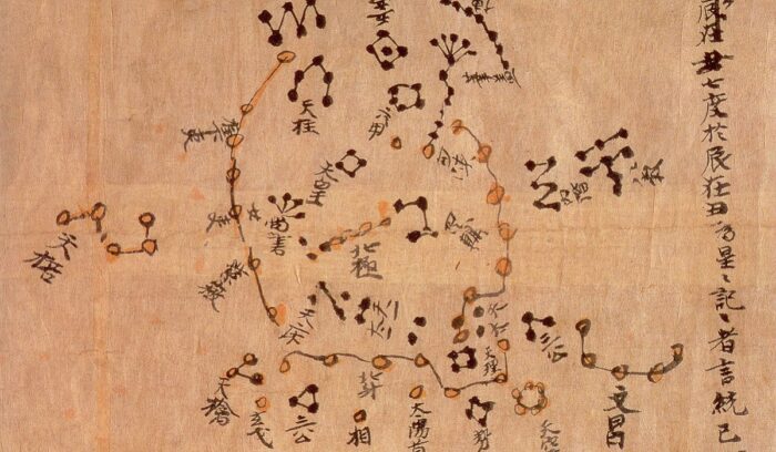
- Dunhuang star map: The scroll is currently regarded as the world’s oldest known complete star atlas, mapping over 1,300 stars across 13 sections of the night sky using a projection method that anticipates later cartographic techniques.
- Tang dynasty astronomy: The map dates to the Tang dynasty (618–907 C.E.), a period when Chinese imperial courts maintained professional astronomers whose work carried both scientific and political weight — the heavens were seen as a mirror of earthly order.
- Three Schools of Astronomical Tradition: Stars on the map are color-coded in three distinct inks, each representing one of the classical Chinese astronomical schools associated with court astronomers Shi Shen, Gan De, and Wu Xian — a visual record of competing and coexisting knowledge traditions.
A map hidden in a cave for a millennium
The scroll was among hundreds of thousands of manuscripts sealed inside the Mogao Caves near Dunhuang, in what is now northwestern China’s Gansu province. Scholars believe the cache was walled up around 1,000 C.E., possibly to protect the documents from invasion. It stayed there, undisturbed, for roughly nine centuries.
In the early 20th century, a British-led expedition led by archaeologist Aurel Stein removed thousands of manuscripts from the caves. The star map scroll ended up in the British Library in London, where it remains today. That origin story carries complicated weight — the removal of the Dunhuang manuscripts without the consent of local communities is a matter of ongoing cultural heritage debate between the U.K. and China.
The map received its first significant mention in Western academic literature when historian of science Joseph Needham discussed it in his landmark 1959 work Science and Civilisation in China. Despite that introduction, scholarly analysis remained limited for decades.
What makes the Dunhuang star map extraordinary
The map is organized into 13 panels. Twelve follow the months of the lunar year, showing how the sky changes with the seasons. The thirteenth panel depicts the circumpolar stars — those that never set from the latitude of China — using a polar projection. The equatorial panels use a cylindrical projection, a technique that would not appear in European cartography for centuries.
More than 1,300 individual stars are plotted. That count, and the projection methods used, have led researchers to describe the document as a serious scientific instrument, not merely a decorative or symbolic object. A 2005 analysis published in the Monthly Notices of the Royal Astronomical Society found the map’s star positions to be surprisingly accurate — within a few degrees of modern measurements for most entries.
The color-coding system tells a parallel story about knowledge itself. By distinguishing the three classical schools visually, the map’s maker wasn’t just recording the sky — they were documenting a tradition of intellectual plurality, showing that multiple frameworks for understanding the heavens had been preserved, compared, and transmitted across generations of Chinese astronomers.
Lasting impact
The Dunhuang star map stands as physical evidence that systematic, empirical sky observation in China had reached a high level of organization by the Tang period — and likely well before. It provides visual confirmation for textual records of Chinese astronomy that scholars had previously been unable to verify directly.
Its projection techniques — particularly the cylindrical equatorial projection used for the monthly panels — have drawn comparisons to the methods later developed independently in Europe. Whether that represents a parallel development or part of a longer chain of knowledge transmission across the Silk Road remains an open and fascinating question for historians of science.
The map also shifted how researchers understand the breadth of Tang-era intellectual culture. The court that produced it was the same court that welcomed diplomats, merchants, and scholars from Central Asia, Persia, and beyond. The Mogao Caves themselves, now a UNESCO World Heritage Site, contain Buddhist art influenced by traditions stretching from India to the Mediterranean — a reminder that Tang China was not an isolated civilization but a hub of the ancient world’s most active networks of exchange.
Blindspots and limits
We do not know who made the Dunhuang star map, under what circumstances, or whether it was intended as a practical tool, an educational document, or an archival record. The scroll’s exact date of creation remains an estimate — “around 700 C.E.” is a scholarly approximation, not a verified date, and some researchers have proposed a range anywhere within the Tang dynasty’s nearly three-century span. The map’s removal from China in the early 20th century also means it has been studied largely outside the country whose astronomers created it, a gap in provenance that shapes how the document has been interpreted and by whom.
Read more
For more on this story, see: Dunhuang Star Chart — Wikipedia
For more from Good News for Humankind, see:
- Renewables now make up at least 49% of global power capacity
- Global suicide rate has fallen by 40% since 1995
- The Good News for Humankind archive on China
About this article
- 🤖 This article is AI-generated, based on a framework created by Peter Schulte.
- 🌍 It aims to be inspirational but clear-eyed, accurate, and evidence-based, and grounded in care for the Earth, peace and belonging for all, and human evolution.
- 💬 Leave your notes and suggestions in the comments below — I will do my best to review and implement where appropriate.
- ✉️ One verified piece of good news, one insight from Antihero Project, every weekday morning. Subscribe free.


